

par BULGOLD Inc. (CVE:ZLTO)
BULGOLD Defines the 2.2km-Long BL Vein Corridor at the Lutila Gold Project
TORONTO, ON / ACCESS Newswire / October 15, 2026 / BULGOLD Inc. (TSXV:ZLTO) (the "Company" or "BULGOLD") announces the mapping, prospecting and historical dataset synthesis for the BL Vein target, located on the eastern flank of the North East Block within the Lutila Gold Project, Slovak Republic.
While initial surface exposures of the corridor were documented as early as the 1600s, systematic field prospecting by the Company has now traced the subvertical BL Vein over a near-continuous 2.2-km north-south strike length. This vein structure represents a new target area within the North East Block situated between 1.1km east and 1.7km southeast of recent drill hole KPDD005, having seen minimal modern exploration and none in the last twenty years.
1. Highlights
- 2.2km Subvertical Structural Trend Mapped: Systematic mapping and prospecting has delineated a near-continuous 2.2km north-south trending structural corridor on the eastern flank of the project area.
- Historic Gold Drill Intercepts: Historical diamond drilling data from 2004 confirms low-grade gold (Au) mineralisation within the BL vein-structure, highlighted by 26.2m @ 0.91g/t Au (from 97m in KG-BL-1) and 24.3m @ 0.76g/t Au (from 51.7m in KG-BL-2). Cross-sectional review of the mineralisation indicates an approximately 100m-wide zone of brecciated rhyolite rock with chalcedonic quartz infill and minor stibnite (antimony sulfide).
- Robust Surface Geochemistry: A combined dataset of 62 rock samples (BULGOLD and Historic) across the trend averaged 0.56g/t Au, 4.9g/t Ag, 364ppm As and 512ppm Sb.
- Preserved System Topography: Outcropping between 425mRL and 540mRL, the BL Vein system reflects a lower level of erosion than the nearby Kopernica Vein System. Historical exploration and/or mining activity tends to cluster preferentially at lower elevations.
- Arsenic-Antimony Pathfinder Coincidence: Surface gold values are coincident with elevated arsenic and antimony volatile pathfinder signatures, matching the property-wide low-sulfidation epithermal vector model.
- Project Location and Logistics: The Lutila Gold Project provides early-stage exploration potential within an established European Union mining district. The site features existing local infrastructure, year-round road access and a standardized regulatory framework, which reduces initial development requirements and estimated operational costs.
- Situated Within a Well-Established Historic Trend: The Lutila Gold Project sits squarely between Central Slovakia's premier precious metal hubs: the Kremnica and Banská Å tiavnica epithermal vein fields. These adjacent districts boast a 1,000-year mining legacy, providing a strong geological validation that the Lutila volcanic corridor is deeply rooted in a highly productive, gold-bearing regional framework.
- Exploration target: underground, high-grade gold (Au) ± silver (Ag) quartz veins.
Quote from the President & CEO, Mr. Sean Hasson:
"Delineating the 2.2-kilometre-long BL Vein target significantly scales up the prospective footprint of the North East Block. While our primary 2026 campaign focused on defining the 500-metre-wide upflow zone at Kopernica, the BL Vein provides a substantial, parallel structural target with verified subsurface thickness and low-grade gold mineralisation in historic drilling.
Our technical review shows that at surface the trend is backed by good gold and silver values, diagnostic crustiform-colloform and lattice-bladed replacement textures, multi-stage hydrothermal breccias and strongly supported by arsenic-antimony pathfinder geochemical signatures. This indicates that the underlying boiling zone remains intact and untested by modern exploration methods."
2. Exploration History & Historic Drilling Footprint
Historical archives indicate that initial recognition of quartz veining within the Jastrabá Formation rhyolites occurred at the BL target during the 1600s. Subsequent small-scale open-pit operations and underground gallery development focused on the eastern slopes during the 19th and 20th centuries. Modern subsurface drill testing, however, remains restricted to limited campaigns.
The 1990s Programme
During the 1990s, 10 historic diamond drill holes totaling 1,984.3 metres were drilled along the eastern flank of the North East Block above the village of BartoÅ¡ova Lehôtka. These holes were predominantly collared as horizontal drill holes into the hillside. Due to poor core recovery and historical data loss, no reliable multi-element or gold assay data are preserved. Legacy geological logs only confirm scattered occurrences of rhyolite-hosted quartz veins and hydrothermal brecciation.
The 2004-2006 Programme
In 2004, three diamond drill holes totaling 770.8 meters tested the subsurface continuity of the BL Vein directly beneath a major surface quartz vein float field.
Drill holes KG-BL-1 and KG-BL-2 were executed as scissor holes targeting the central section of the BL Vein trend. Partial assay records confirm broad zones of gold mineralization hosted within the rhyolite flow-dome complex and adjacent pyroclastic rocks. Hole KG-BL-3 was subsequently drilled deeper beneath the first two holes; the Company understands that the highest-grade interval in this deeper hole returned 0.45m @ 2.21 g/t Au (from 191.35m).
No further assay information is available for KG-BL-3 and historical records indicate that the exploration programme was curtailed immediately following the completion of this third hole. The Company is aware of an additional, small drill programme during 2006 which targeted the northern portion of the BL Vein trend; however, only very limited gold assay information is available and no material outcomes can be reported. Consequently, no modern exploration has taken place along the BL Vein trend since that time.
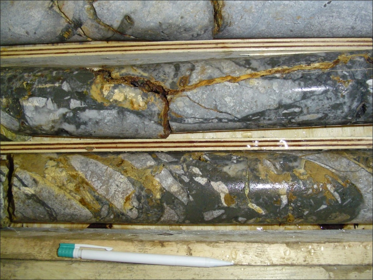
Drill hole information is shown in Table 1 and significant intercepts calculated using a 0.5g/t Au cut-off are presented in Table 2. Figure 1 (below) shows a mineralised section of the KG-BL-1 drill core. For additional information on historic exploration within the Lutila Gold Project please see the Company's press release dated: May 1, 2024.
HOLE ID | DEPTH | X_UTM34N | Y_UTM34N | Z_UTM34N | Azimuth | Dip |
KG-BL-1 | 200 | 345791 | 5391545 | 508 | 240 | -60 |
KG-BL-2 | 220.8 | 345684 | 5391551 | 538 | 120 | -45 |
KG-BL-3 | 350 | 345891 | 5391387 | 473 | 300 | -45 |
Table 1. Historic drill hole information.
HOLE ID | From (m) | To (m) | Interval (m) | Au g/t |
KG-BL-1 | 84.4 | 89.7 | 5.3 | 1.26 |
KG-BL-1 | 97 | 123.2 | 26.2 | 0.91 |
KG-BL-1 | 138 | 143.1 | 5.1 | 0.63 |
KG-BL-2 | 51.7 | 76 | 24.3 | 0.76 |
KG-BL-2 | 156.3 | 168 | 11.7 | 0.94 |
KG-BL-3 | 191.35 | 191.8 | 0.45 | 2.21 |
Table 2. Historic drill hole significant intercepts; 2m minimum composite length, 2m maximum internal dilution, 0.5g/t Au cut-off.
3. Surface Exploration & Geochemistry
Systematic surface prospecting across the 2.2km-long strike length of the BL Vein has successfully delineated a highly anomalous geochemical footprint. A combined dataset comprising 62 rock samples, collected through both recent BULGOLD field campaigns and historical programmes, has returned consistent results across the outcropping and subcropping structural corridor.
The entire 62-sample dataset yielded a robust property-wide multi-element average of 0.56g/t Au, 4.9g/t Ag, 364ppm As and 512ppm Sb.
To understand the grade distribution within this system, a higher-grade subset filter was applied (Table 3):
- Higher Grade Subset: 20 samples returned grades ≥0.40g/t Au.
- Subset Averages: This core group averages 1.53g/t Au, 13.08g/t Ag, 325ppm As and 445ppm Sb.
These data confirm that coherent, higher-grade gold mineralization extends into the unmined footwall margins and peripheral alteration halo surrounding the legacy workings. Surface rock textures are dominated by polymict hydrothermal breccias and quartz vein float boulders displaying moderately developed crustiform-colloform banding and lattice-bladed silica replacement textures. The strong spatial correlation between elevated gold values and the robust volatile pathfinder anomaly (364 - 512 ppm As-Sb) conforms to the property-wide low-sulfidation epithermal vector model. This geochemical signature demonstrates that the current surface exposures of the BL Vein system represent the intact upper levels of a boiling upflow zone that has experienced a slightly deeper level of erosion compared to the more preserved, nearby Kopernica Vein System.
SAMPLE ID | X_UTM34N | Y_UTM34N | Z_UTM34N | Au_ppm | Ag_ppm | As_ppm | Sb_ppm | Comment |
5072 | 345737 | 5391390 | 519 | 4.44 | 36.8 | 78 | 444 | HISTORIC |
95705 | 345728 | 5391447 | 529 | 3.90 | 28.9 | 251 | 317 | BULGOLD |
5071 | 345731 | 5391370 | 511 | 3.60 | 33.1 | 49 | 562 | HISTORIC |
SL97-64 | 345775 | 5391409 | 519 | 3.48 | 3 | N/A | N/A | HISTORIC |
5070 | 345728 | 5391360 | 506 | 2.89 | 22 | 69 | 512 | HISTORIC |
5073 | 345727 | 5391405 | 521 | 2.63 | 26.5 | 111 | 264 | HISTORIC |
5074 | 345744 | 5391434 | 524 | 1.37 | 22.8 | 60 | 439 | HISTORIC |
5076 | 345740 | 5391520 | 534 | 1.06 | 12.5 | 93 | 568 | HISTORIC |
5075 | 345737 | 5391441 | 527 | 1.04 | 6.8 | 21 | 277 | HISTORIC |
95987 | 345770 | 5392315 | 505 | 0.85 | 11.4 | 196 | 94 | BULGOLD |
SL97-79 | 345787 | 5391570 | 507 | 0.75 | 10.7 | N/A | N/A | HISTORIC |
5077 | 345751 | 5391583 | 520 | 0.64 | 15.5 | 56 | 373 | HISTORIC |
5080 | 345781 | 5392383 | 533 | 0.60 | 4.7 | 335 | 104 | HISTORIC |
5062 | 345845 | 5390833 | 431 | 0.57 |